Construction Dive’s new series, Tech 101, provides quick, top-line information about emerging construction technology. Click here for the first article in the series. What type of tools would you like a primer on? Email [email protected].
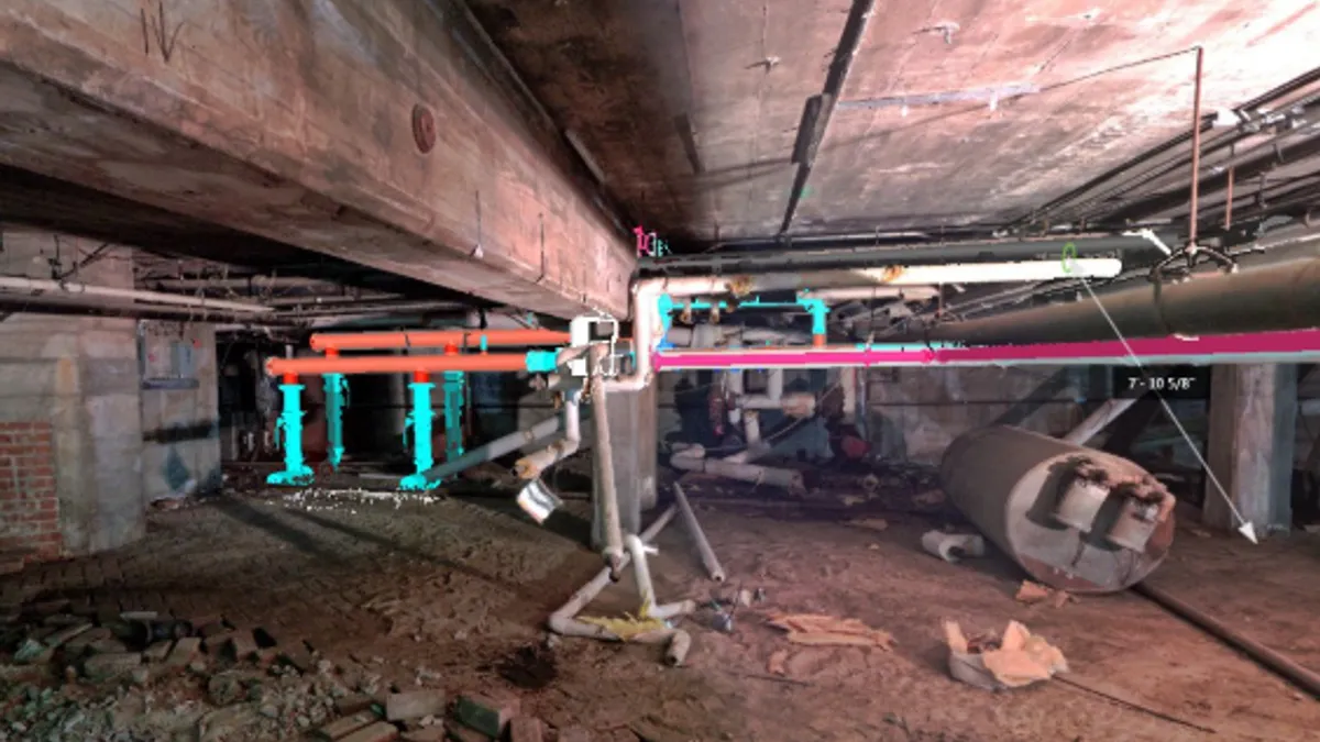
First deployed in the construction industry in the mid-1990s for site surveying purposes, reality capture via laser scanning involves the use of scans that are converted into models containing detailed information about sites or buildings.
The technology has been used for years by large construction firms like Clark, Skanska and PCL in areas ranging from building design and renovations to infrastructure projects and historical preservation.
What you should know
Reality capture data models can be made from 3D scans, laser scans, drone photographs and 360-degree photographs. Using hardware such as a laser scanner, 360-degree camera or camera-mounted drone, a worker can scan a site or building in order to capture a detailed set of physical points of reference modeled as data points.
Costs for construction scans vary greatly depending on the project size and accuracy requirements. The price for a scanner ranges from about $20,000 to $80,000, according to Paul Tice, CEO of ToPa 3D, a 3D laser scanning consulting firm in Portland, Oregon. Large companies often have dedicated VDC departments but small and medium sized firms often rely on consultants for scanning, he added.
It's important to start with a clearly defined project scope, according to Ryan Hacker, president of TruePoint Laser Scanning in Toledo, Ohio.
"Construction managers should understand and communicate what they are trying to accomplish through the use of laser scanning and what type of deliverable they want to work with," he told Construction Dive. "Do they need the raw point cloud data or more advanced processing of the scan data such as 2D drawings, 3D models, or PDFs in programs such as AutoCAD, Revit, Civil 3D and Plant 3D?"
Construction applications
Reality capture has useful applications for nearly every aspect of design and construction, writes blogger Brian K. Smith. Among other things, it's used for:
Clash detection. The technology is often employed as a way to lessen clashes within a project, such as incorrect placement of piping hangers or equipment that’s not the right size. Scans also allow potential issues to be detected early on, reducing rework.
“Scanning shows you the actual conditions, not what you draw,” Kent Kruse, president of Kansas mechanical contracting firm Kruse Corp., told Construction Dive. “If you can identify those hurdles before time and money is spent it’s a huge thing.”
Time reduction. Overhead drone scans can cut down on traditional site-surveying methods.
On PCL projects, Site Scan software from 3DR turns drone photos into maps and 3D models of construction sites, said Bill Bennington, PCL's national quality manager. Reality capture can cut down on trips to the jobsite, since scans provide accurate, detailed representations of the building environment.
"When talking about a scenario during a jobsite meeting, one can easily pull up images of the area being discussed," Bennington said. "This adds context to the discussion and often allows the team to resolve issues during the meeting without the typical response of 'Let’s walk out and look at this after the meeting.'"
Plan reproduction. Reality scans can provide “digital blueprints” for remodeling and restoration work, on buildings for which hand drawings are not available, like the recently fire damaged Notre Dame Cathedral.
Precision. The technology provides the most precise layout of artwork and landscapes possible. At the Eisenhower Memorial construction site in Washington, D.C., for example, Clark Construction is using scans to help precisely place a woven metal tapestry and handpicked trees on site.
“Knowing the exact location of the branches, we can have the architect position them in the model and we can see where the cranes should come in to pick them up before we plant them,” Brian Krause, Clark vice president and director of virtual design and construction, told Construction Dive.
Roadblocks
There are a few things that construction pros need to know about working with laser scans, Tice said. First off, the files are large and require a computer with enough memory to hold them or a cloud-based laser scan viewing platform.
Tice said that construction managers should also keep in mind that laser scanning is slower than photography and can take hours or days to produce images.
"Processing laser scan data can be slow at times and so it’s important to request areas to be scanned a few days in advance in most cases to ensure a timely delivery for analysis," he said.
In addition, its high level of accuracy may not be appropriate for every application so it’s important to consider the end use before committing to a scanning project, he said.
Hacker said there is sometimes confusion around terminology. For instance, many of his clients think they want "As-Built" deliverables, but in reality want "Design Intent" models.
"Design Intent is where things are shown close to reality, but within the assumptions that walls are plumb and square, floors are flat, pipes do not sag and columns aren’t bent from being hit by forklifts," he said. "Or on the other hand, As-Built shows the actual deformation or problem in order to help remedy specific issues."
Notable projects
Laser scans slash schedule for Kansas subcontractor
Eisenhower Memorial construction takes a high-tech approach
Skanska scans its way through Goliath NYC projects
$1.6B LAX expansion team highlights BIM, AR/VR and other tech for staying on budget, schedule
For more reading
Five reasons to add reality capture technology to your toolbelt
Four reality capture technologies construction managers need to know
How reality capture is changing the design and construction industry


